
phy-geog.htm
Edited by U Kyaw Tun (UKT) (M.S., I.P.C., USA),
and staff of Tun Institute of Learning (TIL).
Not for sale. No copyright. Free for everyone.
Prepared for students and staff of TIL
Research Station, Yangon, MYANMAR
-
http://www.tuninst.net ,
www.romabama.blogspot.com
index.htm | |Top
earth-indx.htm
| geog-indx.htm
Principal sources: Downloaded text TIL HD-PDF and SD-PDF
libraries:
¤Physical Geography of Southeast Asia
edited by Avijit Gupta, Oxford Univ. Press, 2005, 440 pages.
-
AGupta-PhyGeographSEAsia<Ô> /
Bkp<Ô> (link chk 180214)
¤ The Inventory of Preliminary Geological Sites Assessment in Myanmar, by Myint
Soe, et al., 2018
-
MSoeEtAl-GeogSitesMyan<Ô> /
Bkp<Ô> (link chk 190511)
Introduction
Getting your bearings
Geological Framework
Landforms of Southeast Asia
UKT notes
• Paungsau Pass -
an invasion route
• Proto-Irrawaddy River entering the Gulf of Martaban
-
UKT 180214, 190503:
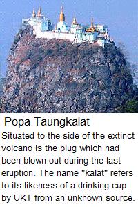
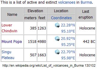
The most prominent geological feature in Myanmarpré is Mount Popa, and to get your bearings in a map of Myanmarpré look for it. If it is not marked, figure out where it should be: 20.92 deg. N., 95.25 deg. E.

hkyak twín: mranma / poap~pa: pa /
mrauk ka. nhic hswèý shé. ko:hsè /Mnemonic:
Navel of Myranmar, Mount Popa;
North 20, East 95; get the bearings right.
In
the East such a prominent feature
must have a guardian spirit or Nat
![]() {nût}. Do not confuse
{nût}. Do not confuse
![]() {nût} with
{nût} with
![]() {dé-wa.}
- unseen entities in Buddhism and Hinduism.
{dé-wa.}
- unseen entities in Buddhism and Hinduism.
![]() {nût} is Bur-Myan pre-Buddhist religion, and is the spirit of a dead ancestor who still guards his
children. It is akin to the ancient Roman idea of Ma'nes - the good ones. The bad
ones are the Lemures - something like the modern poltergeist.
{nût} is Bur-Myan pre-Buddhist religion, and is the spirit of a dead ancestor who still guards his
children. It is akin to the ancient Roman idea of Ma'nes - the good ones. The bad
ones are the Lemures - something like the modern poltergeist.
From: https://www.ancient.eu/article/34/roman-household-spirits-manes-panes-and-lares/ 190503
"Earth spirits in ancient Rome, as well as the spirits of those who had died, watched over the every day lives of the Romans cheerfully - unless one forgot to give thanks. ...
"Ma'nes were the collective dead who inhabited the afterlife. Anyone who died became a ma'ne and then were specified as a La're or a Parentes by whomsoever was involved with them.
"Lemures were the uneasy or wrathful or mischievous dead. Today a Lemure would be known as a poltergeist. These spirits, like the Ma'nes, were the general unhappy dead. A La're could become a Lemure if proper offerings and prayers were not made satisfactorily"
The
![]() {dé-wa.}
on the other hand, is a Buddhist, and also a Hindu idea. Of course, the man on the street - the
common man - and the foreign news writer who usually speaks with him during a
hasty trip to Myanmar to write an "authoritative report to the world press"
would be confused when the two words are put together:
{dé-wa.}
on the other hand, is a Buddhist, and also a Hindu idea. Of course, the man on the street - the
common man - and the foreign news writer who usually speaks with him during a
hasty trip to Myanmar to write an "authoritative report to the world press"
would be confused when the two words are put together:
![]() {nût dé-wa}.
{nût dé-wa}.
 The guardian spirits of Mt. Popa are the Lord of the Great
Mountain, who was a blacksmith in his worldly life,
and his sister. That even the guardian Nat was a blacksmith
is a testimony to the abundance of metal deposits,
particularly copper and zinc, in the land.
The guardian spirits of Mt. Popa are the Lord of the Great
Mountain, who was a blacksmith in his worldly life,
and his sister. That even the guardian Nat was a blacksmith
is a testimony to the abundance of metal deposits,
particularly copper and zinc, in the land.
My paternal great-grandfather, U Yan Shin, and his father Hpo Tagaung, and his uncle Hpo Mintha had worshiped the Brother and Sister Nats, and I still regard them as my ancestors and I still have a shrine to them in my home in Yangon, 35 Thantada St., Sanchaung. Do not think, the Brother Nat had six hands. No! He had only two, but he was a blacksmith so the artist must show one hand holding a hammer. He was appointed a minister by the king, and so the artist added another to hold the official fan. And so on.
We could imagine that the area
where Mt. Popa now stands, was a low lying area through which the old Irrawaddy (Proto-Irrawaddy) river had flowed, until
Mt Popa, the
volcano, arose raising the land around it cutting the old Irrawaddy
![]() {É-ra-wa.ti
mric} into two: the Samon
{É-ra-wa.ti
mric} into two: the Samon
![]() {sa.moan
hkyaún:} flowing to the north, and Sittang
{sa.moan
hkyaún:} flowing to the north, and Sittang
![]() {sic-taún:mric} river to the south to empty
into the Gulf of Martaban. The area of the breakup is marked with an oval. It is
south of Yamethin
{sic-taún:mric} river to the south to empty
into the Gulf of Martaban. The area of the breakup is marked with an oval. It is
south of Yamethin
![]() {ra.mæÑ:þín: mro.} and north of Pyinmana
{ra.mæÑ:þín: mro.} and north of Pyinmana
![]() {pyiñ-ma.na: mro.}.
{pyiñ-ma.na: mro.}.
The modern administrative capital, Naypyitaw
![]() {né-præÑ-tau}, lies to
the east of the old Proto-Irrawaddy river.
{né-præÑ-tau}, lies to
the east of the old Proto-Irrawaddy river.
It is alleged that this breakup of the Proto-Irrawaddy had happened relatively recently around 444 BC (precisely 442 BC), which I always remembered by a little ditty in Bur-Myan:
. Roughly translated:
When Four 4s meet , Champas smelling sweet,
Topmost heavens did hear , birth of Mt. Popa.
UKT 190509: Pushing into the history of Myanmarpré as far back as possible, I have landed myself in the geological ages when presumably there were no humans as we know of them today.
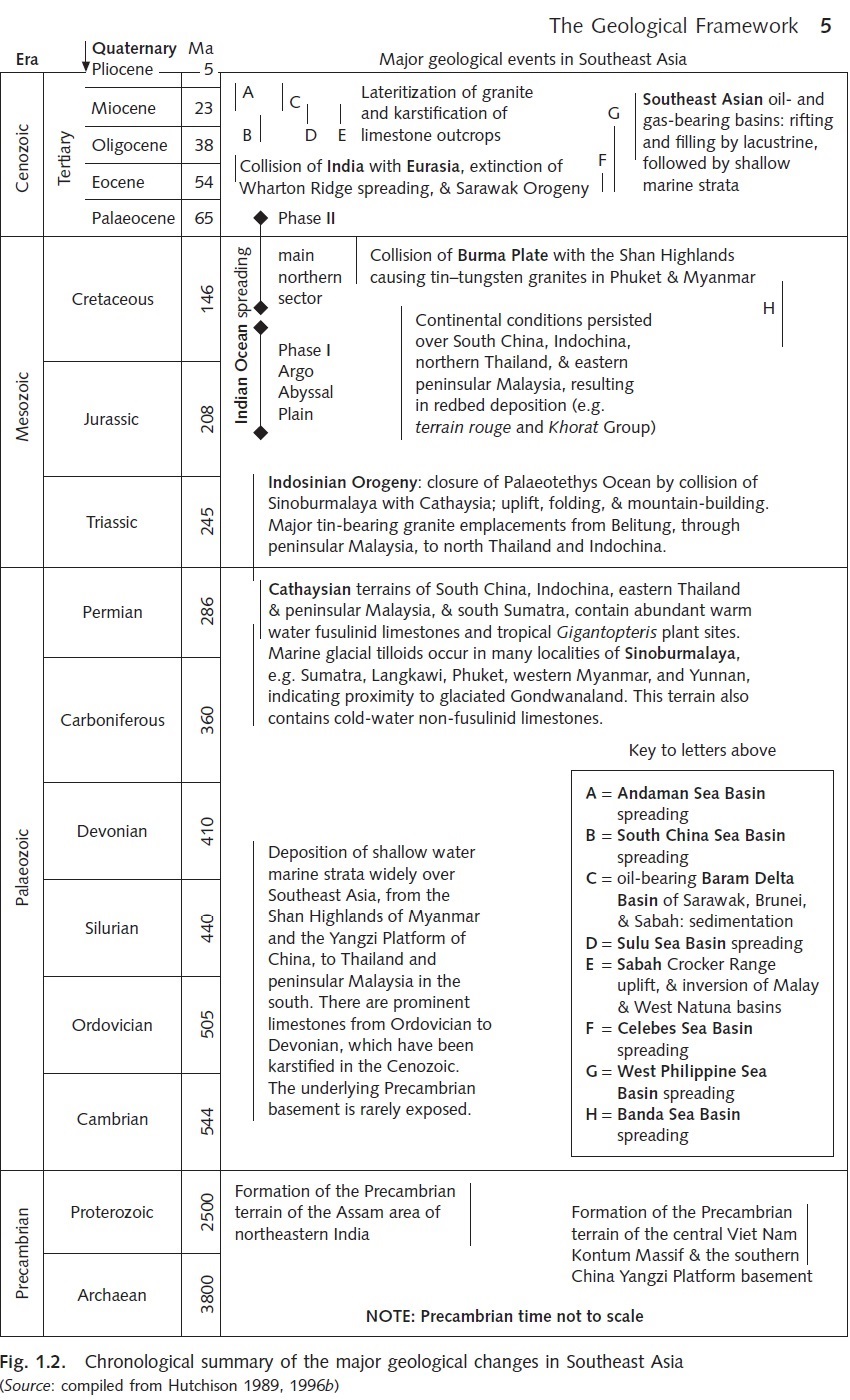
Geological time scale is divided into groups in the order:
Supereon > Eon > Era > Period > Epoch > Age.
There are two Supereons: the Precambrian Supereon, and the present one which is un-named and is left as a white blank. I've redrawn the following figures from Wikipedia articles from time to time: https://en.wikipedia.org/wiki/Geologic_time_scale 190509
The area below the white area, lasting from 541 Ma ago to the present is expanded and is shown below. It is the Phenerozoic Eon.
The area below the last portion of the Phanerozoic Eon, lasting from about 66 Ma ago to the present is expanded and is shown below. It is the Cenozoic Era.
The area below the last portion of the Cenozoic Era, lasting from about 2.588 Ma to the present is again expanded and shown below. It is the Quaternary Period.
Now let's change our count from Millions = 106 to Kilos = 103. So we can say the Quaternary Period lasts from about 2588 Ka. (Note: the unit Ka. is usually shown as ka., but I've capitalize it to be in conformity to Ma. )
There are 2 Epoch in Quaternary Period: Pleistcene Epoch, and Holocene Epoch. The present time is in Holocene Epoch which lasts from 11.650 Ka to the present, which is 11,650 yr. ago.
There are 3 Ages in Holocene Epoch: Greenlandian Age, Northgrippian Age, and Meghalayan Age.
The present Age, known as the Meghalayan Age begins 4,200 years BP, i.e., before 1950 (c. 2250 BCE or 7750 HE). Since Gautama Buddha flourished about 2,500 yr. ago, my interest is in the Maghylayan Age. See Wikipedia:
- https://en.wikipedia.org/wiki/Meghalayan 190509
"Its Global Boundary Stratotype Section and Point (GSSP) is a Mawmluh cave formation in Meghalaya, northeast India. [7] Mawmluh cave is one of the longest and deepest caves in India, and conditions here were suitable for preserving chemical signs of the transition in ages. [8] The global auxiliary stratotype is an ice core from Mount Logan in Canada. [9]
See also: Wikipedia https://en.wikipedia.org/wiki/Meghalaya 190509
"
It's not only the drifting and uplifting land masses that are in play throughout
the geologic time, the weather system especially the monsoon would come in. See
a downloaded paper Asian Monsoon and Cenozoic Tectonic History, by
Detailed Planning Group (?), 2008
-
DetPlanGr-MonsoonCenozoic<Ô> /
Bkp<Ô> (link chk 190503)
"The Earth’s climate has varied through geological time as a result of both external, orbital processes and internal climatic feedbacks, as well as the positions of continents, growth of mountains and oceanic gateway openings/closures controlled by tectonic forces. Typically these processes act over time spans of less than 105 yrs and more than 106 yrs respectively. While significant progress has been made in linking climate change to solar insolation driven by perturbations in the Earth’s orbit, links between tectonic processes and climate have remained more conjectural due to the more complex forcing as well as from a lack of long duration geological records. The archetypal example of climate-tectonic coupling is the proposed link between the intensity of the Asian monsoon and the uplift history of the Tibetan Plateau. ..."
The present work is mainly from Physical
Geography of Southeast Asia edited by Avijit Gupta,
Oxford Univ. Press, 2005, ISBN 0199248028, 9780199248025,
440 pages, with its pdf versions in TIL HD-PDF and SD-PDF libraries.
- AGupta-PhyGeogSEA<Ô>
/ Bkp<Ô> (link
chk 190508)
Of course, there are my additions, and since I intend this to be a seamless narrative, the portions that have been added would get lost in the original text. However, I must emphatically add, I have no intention of masquerading my additions as those authenticated by the authors of the original text. The same goes for the pictures and maps from which I have taken only the part that is of interest. Some of these have been linked to the originals. Try clicking on them and you may come up with the original.
The time frame of formation of what we now know as Myanmarpré is 1 to 100 Ma (million years ago) - roughly the Phanerozoic Eon (541–0 Ma), Cenozoic Era (66-0 Ma) with its 3 periods: Paleocene Period, Neogene Period, and Quaternary Period. And also Permian Period - geol-indx > permian.htm (link chk 180214)
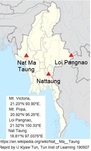
UKT 190507: If you are a traveler, you may also like to know that MST (Myanmar Standard Time) is based on Longitude 97°30' E. Incidentally, MST base line almost runs through a prominent peak, the Nat Taung.
Pix on the right shows the position of NatMa Taung aka Mt. Victoria on which I've added the locations of three landmarks: Mt. Victoria, Mt. Popa, and Loi Pangnao. Notice how they form a line from west to east along Latitude 21° N. I've added the position of Nat Taung to the map of Mt. Victoria. Both maps are from Wikipedia: https://en.wikipedia.org/wiki/Nattaung 190510
To keep your bearings straight, always refer to the
latitude 20°N where we find the most prominent landmark
of the region, Mount Popa
![]() {poap~pa:taún}, 20.92°N 95.25°E, summit elevation
4,980 feet (1518 m).
The name is a combination of two words
{poap~pa:taún}, 20.92°N 95.25°E, summit elevation
4,980 feet (1518 m).
The name is a combination of two words
![]() {poap~pa:} +
{poap~pa:} +
![]() {taún} 'mountain'.
{taún} 'mountain'.
Mount Popa
![]() {poap~pa:taún} is at present an extinct volcano, which
according to local legends last erupted in 442 BC.
-- info from:
http://www.volcano.si.edu/world/volcano.cfm?vnum=0705-08-
080923. Seismic activity is common, but loss of human life is rare.
{poap~pa:taún} is at present an extinct volcano, which
according to local legends last erupted in 442 BC.
-- info from:
http://www.volcano.si.edu/world/volcano.cfm?vnum=0705-08-
080923. Seismic activity is common, but loss of human life is rare.
In my 85 years of life, I have known only two major
earthquakes, the first one locally known as the Pegu
earthquake (named after Pegu town
![]() {pè:hku:mro.}) of 1930-1935 [note: I was born in Feb of 1935], and the second the Pagan earthquake
of 1975 (named after Pagan town
{pè:hku:mro.}) of 1930-1935 [note: I was born in Feb of 1935], and the second the Pagan earthquake
of 1975 (named after Pagan town
![]() {pu.gnän mro.}).
According to my father U Tun Pe, there was only a single loss of life during
the Pegu earthquake and not a single one during the
Pagan earthquake.
{pu.gnän mro.}).
According to my father U Tun Pe, there was only a single loss of life during
the Pegu earthquake and not a single one during the
Pagan earthquake.
During the Pegu earthquake, the most prominent pagoda in Pegu, Shwemawdaw
![]() {shwé-mau-Dau: Bu.ra:} of Pegu town
{shwé-mau-Dau: Bu.ra:} of Pegu town
![]() {pè:hku:mro.} was significantly damaged.
{pè:hku:mro.} was significantly damaged.
See Wikipedia: -
https://en.wikipedia.org/wiki/Shwemawdaw_Pagoda 180214
UKT personal note: It was reported in New York Times to the effect that "Rangoon, the capital and largest city of Burma, in the southern part was heavily damaged with heavy loss of life by an earthquake and tsunami on May 5 1930,". The fact was at that time, my parents U Tun Pe and Daw Hla May, were in Kungyangon, now incorporated into Greater Rangoon (aka Yangon). My wife Daw Thanthan Tun was born that year at 31 Thantada St., Kemmendine (now Sanchaung), Rangoon. Yet, no one in both my family and my wife's has ever told me such "news" as reported in New York Times. I have read the reprint of that article, but as of today (2011 Nov 12), I could not get hold of it. However, you can see on the Internet reports such as : http://jtic.org/index.php?view=details&id=3052&pop=1&tmpl=component&option=com_eventlist&Itemid=523&lang=en
The nearest major town to Mt. Popa is Meiktila
![]() {mait~hti-la mro.}, 20°53'N, 95°53' E.
(http://en.wikipedia.org/wiki/Meiktila 080923).
You may also use its coordinates instead of those
of Mt. Popa in studying the maps.
{mait~hti-la mro.}, 20°53'N, 95°53' E.
(http://en.wikipedia.org/wiki/Meiktila 080923).
You may also use its coordinates instead of those
of Mt. Popa in studying the maps.
The second mountain to fix your position is Mount Victoria 21°14'N, 93°54'E,
elevation: 3053m or 10,016ft, in the Chin Hills. --
http://www.peakbagger.com/peak.aspx?pid=10950 100802.

Mt. Vitoria is also known as NatMa Taung
![]() {nût-ma. taún}, also as Khaw-nu-soum
or Khonuamthung in Chin. It is
the highest mountain in the Chin State
of western Myanmarpré. Located in Kanpalet
Township, Mindat District, Mount Victoria
is part of the Chin Hills range, and rises
to 3,053 metres (10,016 ft)
above sea level. Nat Ma Taung lies in the
Chin Hills-Arakan Yoma montane forest ecoregion. A peak with a similar name, Nat
Taung lies in the Karen State.
{nût-ma. taún}, also as Khaw-nu-soum
or Khonuamthung in Chin. It is
the highest mountain in the Chin State
of western Myanmarpré. Located in Kanpalet
Township, Mindat District, Mount Victoria
is part of the Chin Hills range, and rises
to 3,053 metres (10,016 ft)
above sea level. Nat Ma Taung lies in the
Chin Hills-Arakan Yoma montane forest ecoregion. A peak with a similar name, Nat
Taung lies in the Karen State.
See https://en.wikipedia.org/wiki/Montane_ecosystems 180821, 190507
"Montane ecosystems refers to any ecosystem found in mountains. These ecosystems are strongly affected by climate, which gets colder as elevation increases. They are stratified according to elevation."
Surrounded at lower elevations by tropical and subtropical moist forests, Nat Ma Taung's higher elevations form a sky island, home to many temperate and alpine species typical of the Himalaya further north, as well as many endemic species. The mountain is now protected within Nat Ma Taung National Park, established in 1994. - http://en.wikipedia.org/wiki/Nat_Ma_Taung 100802.
Nat Ma Taung
![]() {nût-ma. taún} aka Mt. Victoria is an
ultra prominent peak, or Ultra
for short, is a mountain with a
topographic prominence of 1,500 metres (4,921 ft) or more. There are a total
of roughly 1,515 such peaks in the world.
[1]
Some are famous even to non-climbers, such as Mount Everest, Aconcagua
(Andes Mountain range) and Denali (aka Mt. McKinley, Alaska) (the
top three by prominence), while others are much more obscure. Not all famous
peaks, such as the Matterhorn and Eiger, are not Ultras because
they are connected to higher mountains by high passes and therefore do not
achieve enough topographic prominence. -
http://en.wikipedia.org/wiki/Ultra_prominent_peak 130102
{nût-ma. taún} aka Mt. Victoria is an
ultra prominent peak, or Ultra
for short, is a mountain with a
topographic prominence of 1,500 metres (4,921 ft) or more. There are a total
of roughly 1,515 such peaks in the world.
[1]
Some are famous even to non-climbers, such as Mount Everest, Aconcagua
(Andes Mountain range) and Denali (aka Mt. McKinley, Alaska) (the
top three by prominence), while others are much more obscure. Not all famous
peaks, such as the Matterhorn and Eiger, are not Ultras because
they are connected to higher mountains by high passes and therefore do not
achieve enough topographic prominence. -
http://en.wikipedia.org/wiki/Ultra_prominent_peak 130102
Another location you can use to fix your coordinates
is [from:
http://en.wikipedia.org/wiki/Mandalay 100723] Mandalay
![]() {mûn~ta.lé: mro.}, 21°59'N, 96°5'E. (Though commonly referred to as Mandalay
{mûn~ta.lé: mro.}, 21°59'N, 96°5'E. (Though commonly referred to as Mandalay
![]() {mûn~ta.lé:}, it is better to specify if its the
{mûn~ta.lé:}, it is better to specify if its the
![]() {mro.}
'city' or
{mro.}
'city' or
![]() {taún} 'hill or mountain' you are referring to.) lies along
the Sagaing Fault, a tectonic plate boundary between
the India and Sunda plates. (The biggest earthquake in
its history, with a magnitude of 7, occurred in 1956.
{taún} 'hill or mountain' you are referring to.) lies along
the Sagaing Fault, a tectonic plate boundary between
the India and Sunda plates. (The biggest earthquake in
its history, with a magnitude of 7, occurred in 1956.
[Wiki info from: Christophe Vigny et al.. "Present-day crustal deformation around Sagaing fault, Myanmar" (PDF). Journal of Geophysical Research, vol 108, 19 November, 2003. pp. 2–4. http://www.geologie.ens.fr/~vigny/articles/2002JB001999.pdf. Retrieved 2009-01-25. I, in Rangoon, have but a faint recollection of it. Presumably there was no loss of life. UKT100723].
The devastation however was greatest in nearby Sagaing, and it came to be known as the Great Sagaing Quake.)
Shan Hills - https://en.wikipedia.org/wiki/Shan_Hills 190507
"The highest point is Loi Leng, at 2,673 m high. [1] Other peaks are 2,565 m Mong Ling Shan, [2] 2,565 m Doi Inthanon and 2,563 m Loi Pangnao. All are ultra prominent peaks of Southeast Asia. [3]Ultra prominent peaks - https://en.wikipedia.org/wiki/Ultra-prominent_peak 190507
"An ultra-prominent peak, or Ultra for short, is a mountain summit with a topographic prominence of 1,500 metres (4,900 ft) or more; it is also called a P1500. [1] There are approximately 1,524 such peaks on Earth. [2] Some well-known peaks, such as the Matterhorn and Eiger, are not Ultras because they are connected to higher mountains by high cols and therefore do not achieve enough topographic prominence. "
UKT 180214: See downloaded papers in TIL HD-PDF and SD-PDF libraries:
1. Geological Evolution of Southeast Asia, by Charles S. Hutchison, 2007
- CSHutchison-GeologEvoluSEAsia<Ô> / Bkp<Ô> (link chk 190511)
2. Tectonic Evolution of Southeast Asia, by Charles S. Hutchison, 2014
- CSHutchison-TectonicEvoluSEAsia<Ô> / Bkp<Ô> (link chk 190511)
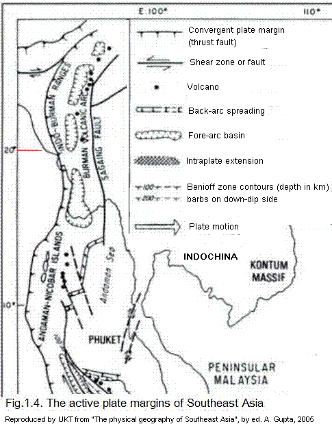
The map shown below from Hutchison is unsatisfactory for me because the northern part of Myanmarpré is not shown. Hutchison's interest is focused on Malaysia whereas mine is on Myanmarpré.
UKT 190512: The geological time-frame of formation of what we now know as Myanmarpré is 1 to 100 Ma (million years ago) - roughly the Phanerozoic Eon (541–0 Ma), Cenozoic Era (66-0 Ma) with its 3 periods: Paleocene Period, Neogene Period, and Quaternary Period. And also Permian Period - geol-indx > permian.htm - (link chk 190512)

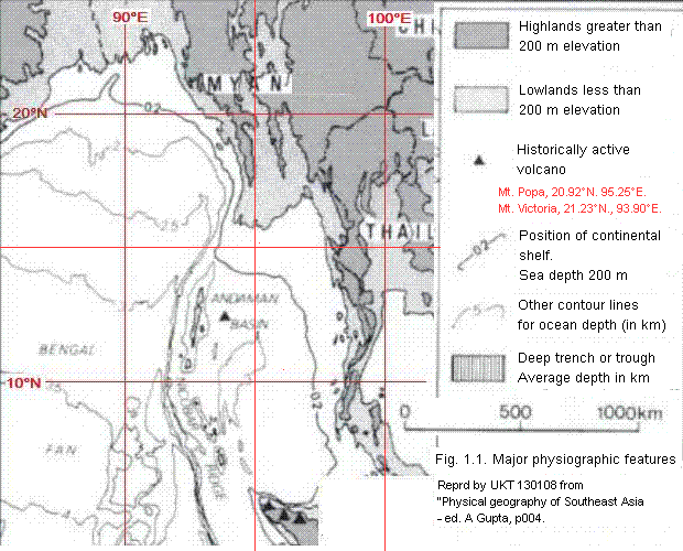
General Plate Tectonics, p.003: The Indo-Australian Plate is converging at an average rate of 70 mm a-1 in a 003° direction, pushed from the active South Indian Ocean spreading axis. For the most part, it is composed of the Indian Ocean, formed of oceanic sea-floor basalt overlain by deep water. It forms a convergent plate margin with the continental Eurasian Plate, beneath which it subducts at the Sunda or Java Trench.
The Eurasian continental plate protrudes as a peninsular extension (Sundaland) southwards as far as Singapore, continuing beneath the shallow Straits of Malaca and the Sunda Shelf as the island of Sumatra and the northwestern part of Borneo (Figure 1.1 - UKT: I have taken the part related to Myanmar, the reader is adviced to consult the original map.)
Indian Ocean, p.003: Based on magnetic anomaly identification, calibrated by drill site data, three distinct episodes of sea-floor spreading can be discerned (Curry et al. 1982).
1. Anomalies M10 to M25 (Neocomian-Oxfordian) have been identified (Heirtzler et.a. 1978) in the Argo Abyssal Plain, beneath the Sunda (Java) Trench and western Australia (Fig.1.3. UKT: I have left out this figure because it is not relevant to Myanmar). ... [{p003end - p007begin}]
2. The spreading pattern was completely reorganized between magnetic anomalies M0 and 34, which is the Cretaceous magnetic quiet period (110-80 Ma ago). From anomaly 34 to 19 (84-44 Ma ago) India made its spectacular rapid northwards flight with rates of 15 to 17 cm a-1: the anomalies are aligned east-west, offset by major north-south transform faults. One of the faults is the Investigator Ridge; others lie close to and parallel to the Ninety-East Ridge.
The prominent Nine-East Ridge is the trace of a single mantle hotspot, which now lies under the Kerguelen Plateau in the south Indian Ocean. The furthest end of it is the Rajmahal Traps, 200 km north-northwest of Calcutta, where the basalt has an age of 105 Ma. The average rate of relative motion of the hotspot trace was about 11 cm a -1 (Curray et. al. 1982).
3. Around magnetic anomaly 19 time (44 Ma ago), spreading completely ceased at the Wharton Ridge in the northern Indian Ocean (Curray and Munasinghe 1989). This striking event in Southeast Asia coincides with the prominent widespread unconformity within the Bengal Fan and with the unconformable continental beginning of many Southeast Asian Cenozoic basins (e.g. Central Sumatra.) ...
[UKT: It is interesting to note that the above map shows at least eight extinct
volcanoes in Myanmarpré, however only three extinct volcanoes are listed in
Wikipedia.].
Bengal and Nicobar Fans, p007: The Bay of Bengal contains the largest subaerial delta in the world, the Ganga-Brahmaputra [UKT: roughly the area of present day Bangladesh], filling the Bengal Basin, grading outwards into the Bay of Bengal and Nicobar Deep Sea Fans, the largest turbidity complex in the world. ... Most of the fan sediments have been derived by erosion of the Himalaya Mountains and transported by the two great rivers.
Active Plate Margins, p007: A nearly continuous arc-trench convergent plate margin extends throughout the region. The correct terminology of the direction is that an observer, standing on the volcanic arc and facing the related trench, has the fore-arc in front of him and the back-arc behind. Fore-arc sedimentary basins lie between the volcanic arc and the accretionary prism. All the deep marginal basins and the oil- and gas-producing sedimentary basins, characterized by shallow-water sediments, lie in the back-arc. Hence the term 'back-arc basin' is of such diversity as to be useless for the petroleum industry [Hutchison 1996b]. In Myanmar the plate margin has been uplifted to form the Indo-Burman Ranges because of the collision of India to the west and the volcanic arc [{p007end}] through Mount Popa is extinct. However, an active plate margin continues southwards west of the Andaman Sea, west of Sumatra, and south of Java, curving northwards in the Banda Sea (Figure 1.4). ...
Myanmar, p009: Cratonic India began its collision with Asia around 50 Ma ago and rotated anticlockwise to cause a major indentation at the Assam-Yunnan syntaxis. Subduction was converted to collision, and the acretionary prism active along the length of Sumatra was strongly uplifted to form the Indo-Burman Ranges, immediately west of which Precambrian India outcrops in the Shillong Plateau and Mikir Hills of Assam (Fig.1.5). Accretionary prism and trenches (subduction systems) are known to be regions of low geothermal gradient. Accordingly an uplifted and eroding accretionary prism should contain outcrops of glaucophane shist (low-temperature-high-pressure metamorphism) and they have been described from several locations in the Naga Hills (Hutchison 1989). Discontinuous bodies of ophiolite, representing dismembered oceanic basement, also occur along the eastern margin of the ranges. The Indo-Burman Ranges accordingly have all the characteristics of a suture, or uplifted plate margin, formed between India and the Burma Plate (Hutchison 1975).

UKT: Fig.1.5. shows the presence of two north-south troughs in Myanmar through which the Chindwin and Irrawaddy rivers flow. Originally, the Irrawaddy flowed due south and became the Sittang and emptied into the Gulf of Martaban. However, at one time, the land rose about the area north of Pyinmana due to which the Irrawaddy turned west (near Mandalay) and combines with Chindwin, and finally empties into the sea forming a large delta.
From the area north of Pyinmana, a relatively small stream known as the Samoan flows northwards and empties into the Irrawaddy near Mandalay. The Sittang, now reduced to a minor river continues to flow southwards and empties into the Gulf of Martaban. (These statements of mine still to be checked my peers.)
The volcanic rocks lie on three distinct lines (Chhibber 1934; Stephenson and Marshall 1984). The Western Line, through Narcondam and Barren Islands is tholeitic and still active. The Central Line, through Mount Popa [UKT: Mount Popa, 20°52'N 95°14'E, is the most prominent landmark], is calc-alkaline and high-K calc-alkaline and extinct in the Pleistoncene. The volcanoes of this line are subduction-related and the Benioff zone was easterly dipping. An Eastern Line, through Thaton and Madaw Island, is alkaline and probably related to continental rifting in the back-arc area related to the Sagaing-Namyin Fault system. A broad zone of earthquakes, wedge-shaped in east-west cross-section, extends eastwards from the western margin of the Indo-Burman Ranges, but there is no longer any well-defined Benioff zone. A formerly eastwardly dipping is inferred because the earthquakes become deeper eastwards.
The Burma or West Burma Plate is bounded on the west by the Indo-Burman Ranges suture, and on the east by the Sagaing right-lateral wrench fault, beyond which the terrain of the Shan Highlands belongs to the Sinoburmalaya or Sibumasu Plate, a northward continuation of western Thailand, western Penninsular Malaysia, and part Sumatra. Most of the Burma Plate is covered by Cenozoic strata, deposited in basins formed in the fore-arc (the Interdeep or Western Trough) and the back-arc (the Back Deep or Eastern Trough), but these terminologies are not useful because the collision of India on the west has caused a change from a convergent plate margin to a collison zone from the [{p009end-p011begin}] Eocene onwards. The sediments were from the proto-Irrawaddy River, confined to a southerly course towards the sea in the Gulf of Martaban, where the strata contain significant productive gas deposits.

Note: The above Gupta-fig3-4-w500.jpg is to be converted to .gif and edited. --
UKT130216
Introduction, p038 : ... This assemblage of landforms has resulted from a combination of plate tectonics, Pleistocene history, Holocene geomorphic processes, and anthropogenic modifications of the landscape. Most of the world has been shaped by such a combination, but unlike the rest of the world, in Southeast Asia all four are important. The conventional wisdom of a primarily climate-driven tropical geomorphology is untenable here. The first two factors, plate tectonics and the Pleistocene history, have been discussed in Chapters 1 and 2 respectively. In the Holocene, Southeast Asia has been affected by the following phenomena:
• The sea rose to its present level several thousand years ago
• The present natural vegetation, a major part of which includes a set of rainforest formations, achieved its distribution
• A hot and humid climate became the norm, except in the high altitudes and the extreme northern parts.
• The dual monsoon systems blowing from the northeast hemispheric winter which is dry making the trees shed their leaves] and from the southwest in the summer (and in general producing a large volume of precipitation) became strongly developed.
UKT 130216:
The monsoons are marked by general changes in the wind directions. During what to us is winter, we get "North wind"{mrauk-lé} -- which is not the cold polar wind. This brings us what we call the Himalayan Rasi. Temperatures can drop to 10 deg C. even in a place like Mandalay. During such times we can get ground frost in Pyin-U-lwin (formerly Maymyo) and Taunggyi. In summer, the wind usually enters the country from the south-west. But once inland it changes direction due to the mountain ranges. We call it the "South wind"
{taung-lé} which brings in heavy rains - the rice growing season in the Irrawaddy delta.
• Countries away from the equator (Myanmar, VietNam, and
the Philippines) became prone to tropical storms, which
could reach hurricane force.
• Anthropogenic alteration of vegetation, slopes, and
river systems intensified over the last 200 years.
UKT: Myanmar (but not VietNam nor the Philippines) is protected from the cold north winds by the high mountain ranges. These rugged mountains also protect the country from alien armies coming in from China and India. Thus chariot warfare (used in India as vividly described in the Mahabharata Epic) was unknown in the country. Bows and arrows (used extensively both in India and China) were generally ineffective because of dense vegetation. The form of warfare known in the country was the use of elephant calvary and the main weapon used was the hand-thrown spear. Also used was the single edged sword. The vegetation in these mountain ranges harbour a very virulent form of malaria which can kill a victim overnight and a form of diarrhea which attacks all those who come into these parts from the lowlands. See Tertian malaria - the sentinel of Myanmar - malaria.htm.
Of course such sudden deaths give rise the stories of powerful guardian Nats who
must be appropriated by people coming into the regions. The word for malaria in
Bur-Myan is
![]() {nghak-hpya:}.
{nghak-hpya:}.
The northern part of the country was well
protected from armies crossing over from
India or China as the British and Americans
came to know during World War II. The
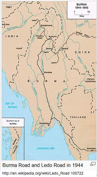
is an excerpt from Wikipedia
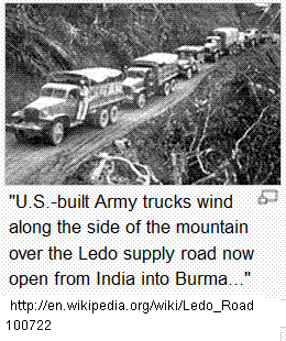
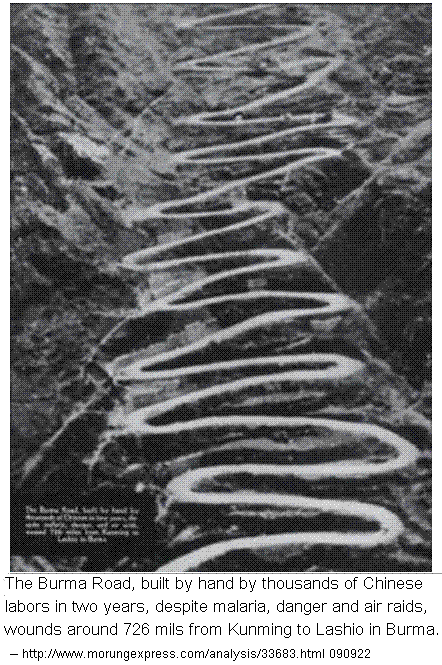
http://en.wikipedia.org/wiki/Ledo_Road 100722:
"In the nineteenth century
British railway builders had surveyed the
Pangsau Pass, which is 3,727 feet
(1,136 meters) high on the India-Burma
border, on the
Patkai crest, above
Nampong,
Arunachal Pradesh (then part of
Assam). They
concluded that a track could be pushed through to Burma and down the
Hukawng Valley. Although the proposal was dropped, the British
prospected the
Patkai Range for a road from Assam into northern Burma. British
engineers had surveyed the route for a road for the first eighty miles.
After the British had been pushed back out of most of Burma by the Japanese,
building this road became a priority for the United States. After Rangoon
was captured by the Japanese and before the Ledo Road was finished, the
majority of supplies to the Chinese were delivered via airlift over the
eastern end of the Himalayan Mountains known as
the Hump."
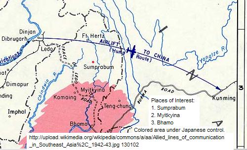
UKT: The area known as the Hump is the topmost part of Myanmarpré.
Myitkyina is the capital of Kachin State in
the far north of the country located 1480 km from Yangon or 780 km from
Mandalay. It is just less than 42 km of Myit_Sone, the confluence of two
headstreams (MaiKha and MaliKha). It is the northernmost of the river port and
rail terminal in Myanmar.
From: http://en.wikipedia.org/wiki/Pangsau_Pass 090929
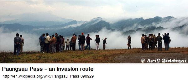
Pangsau Pass, 3727 feet in altitude, lies on the crest of the Patkai Hills on the India-Burma (Myanmarpré) border. The reputed route of the 13th century invasion of [northern] Assam in India by the Ahoms, a Shan tribe, the pass offers one of the easiest routes into Burma from the Assam plains. Prospected by the British in the late 19th Century as a possible railway route from India to Myitkyina in north Burma through the Hukawng Valley, the pass became famous during World War II for being the initial obstacle encountered by American General "Vinegar Joe" Stilwell's forces in their effort to build a land route to isolated China after the fall of Burma to the Japanese. The Ledo Road began at Ledo, the railhead, and passed through Lekhapani, Jagun, Jairampur (the Assam- Arunachal Pradesh boundary and beginning of Inner Line), and Nampong before switchbacking [using hairpin turns] steeply upwards through densely forested hills to the pass, 12km away. The distance from Ledo to Pangsau Pass is 61 km (38 miles). Because of the fierce gradients and the mud which made getting up to the pass difficult, it was nicknamed "Hell Pass" during the war. The first Burmese village, Pangsau, lies 2 km beyond the pass to the east.
Go back Paungsau-pass-note-b
End of TIL file


